 Jane Bennet, author of Vibrant Matter, might agree with me when I say that documents in the archives have thing-power. Thing-power, to her, is “the curious ability of inanimate objects to animate, to act, to produce effects dramatic and subtle” (Bennet 2010: 6). A map is an inanimate object imbued with such thing-power. I do not refer here to the sense of exhilaration that a map is able to elicit in someone perusing the archives or an atlas, but rather to the capacity of the map to produce spatial order by locating things and people in relation to each other.
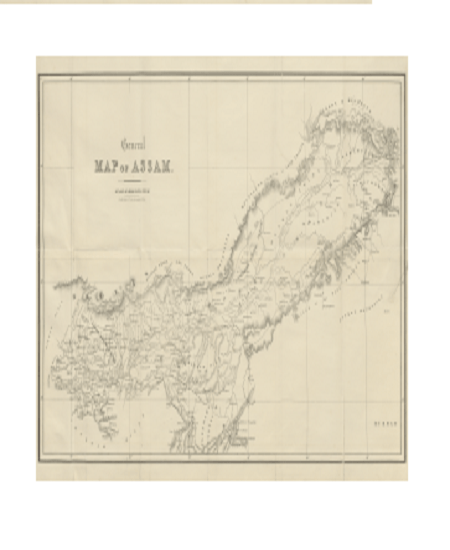
The map above makes the territory of Assam visible by positioning geographical features such as hills, mountains, rivers, and islands in relation to each other. The geographical features that are not sketched are almost as important as those that are sketched on the map. Together, they give this emerging territory of Assam its shape. Assam runs east-west along the river Brahmaputra, delimited in the north and the south by hills that are not fully sketched. The “outside” is allowed to remain an absolute space while Assam is sketched into existence.
Published in 1847, a century before Indian independence, this map sits within a book entitled Sketch of Assam. The author of the book only identifies himself as “an officer… in civil employ.” But he is identified in the archives as Major. John Butler, who was posted in the East India Company’s Bengal Native Infantry. Sketch of Assam is the author’s attempt to sketch—and by this I mean describe and typify both in writing and through drawings—some of the tribes that he encountered during his travels in Assam. By locating these tribes in the hills and in the valleys that fall within the delineated region of Assam as well as outside this demarcated space, he produces a sense of spatial relation between these tribes. For example, the hills to the south of the sketched region of Assam are occupied by the Nagas, locating the Nagas outside of Assam. To the north in another sparsely sketched section are the Abors. On the other hand the Meeree (spelled Meree elsewhere in the book) occupy a huge territory along the Brahmaputra within the territory of Assam. Today, the Nagas are understood to be indigenous to Nagaland and the Abors to Arunachal Pradesh both of which fall outside the territory of the Indian state of Assam. The Meeree are still understood to be a river tribe that live along the Brahmaputra in the state of Assam. Today, they are called the Mishing. I work in Mishing villages along the island of Majuli (Majouli, just south-west of the Meeree territory in the map), and am often reminded by my interlocutors that I should look for the word Meeree/Meree or Miri if I begin to dig into their history.
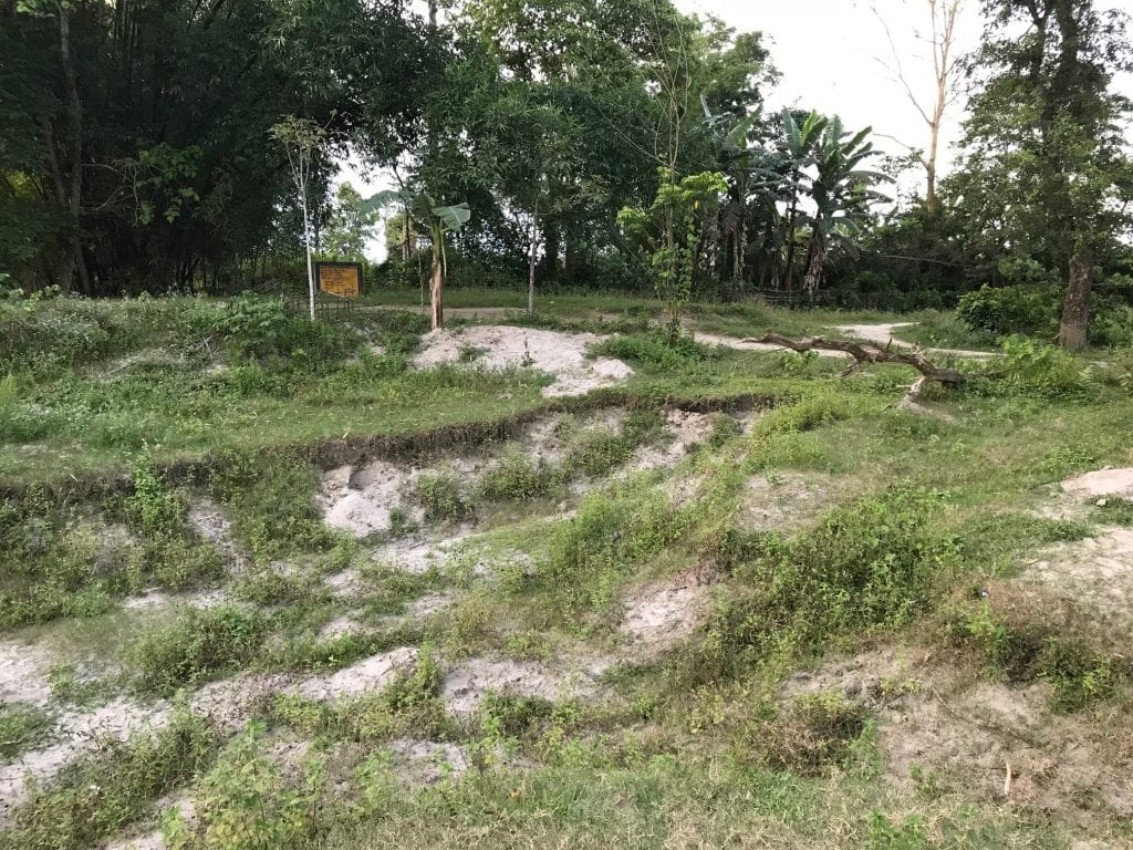
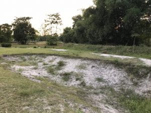
I was indeed digging for history, and I was excited to come across this book—and this map—in the Nehru Memorial Library this August. I was even more thrilled when I was able to locate it in a digital library and download it into my computer. For several reasons this map is a pleasure to examine. My dissertation examines how the Mishing deal with the massive erosion that haunts the island of Majuli today. This erosion forces them to question how they came to be on Majuli, where they came from, and where they were located before they were located in Majuli. Some of my interlocutors talk about the migration of the community from the hills to the north. Traveling down from the area marked “mountains inhabited by Abor Tribes” the Mishing believe they travelled down the river Subansiri, a tributary of the Brahmaputra to settle in both the territory marked as “Meeree tribe” on the map as well as the island of Majuli. No one has a living memory of this migration. But it is collective memory, transmitted orally from one generation to another. This story allows them to claim relatedness to the Abor tribes of the north. In fact, in my first year I had a translator who came from the town of Ziro in Arunachal Pradesh. He was from the Apa Tani tribe. My Mishing interlocutors immediately took him under their wing, telling me he was “their own” while he was away from home, because of the historic relations between these tribes.
Butler too was interested in these relations. Despite his tendency to homogenize entire communities, he pays attention to nuanced power relations between these communities. He notes that the Abor were a powerful tribe and often lorded over the Meeree. While the Meeree migrated south in order to avoid being subjected to Abor lordship, the coming of the Khamtees from Burma into Assam, threatened their sense of independence. Afraid of being enslaved by the Khamtees, the Meeree sought help from the Abor. Butler notes that these tensions resulted in a violent conflict:
This treatment being less endurable than that, of the Abors, towards whom a friendly feeling had been created by long intercourse, the Merees were induced to implore the protection of the latter to save them from being cruelly taken away from their homes to serve as slaves amongst a strange tribe. The Abors, on their side, perceiving that they were about to lose the greater portion of their slaves by the aggressions of a formidable foe, lost no time in preparing for war; and descending from their mountain fastnesses to the plains bordering on the Dehong river, a furious battle was fought between them, and, it, is said, two or three hundred Khamtees. The contest terminated in the Khamtees being defeated and dispersed with great slaughter, upwards of one hundred men being left on the field of battle. This trial of strength and courage with their warlike neighbours, rendered the Khamtees ever afterwards more circumspect in their demeanour towards the Abors, and the people subject to them. (Butler 1847: 41).
It is interesting to see that while Butler locates the Abors and the Khamtees outside of Assam and the Meeree within Assam he avoids the use of militarized terms, i.e., language that implies a breach of Assam’s borders and its sovereignty. Instead he is very careful to note shifting alliances and the power relations between these communities. While he sketches Assam as a delimited territory, he is not too keen to treat migrations as breach of territorial sovereignty. Instead, he seems to indicate that territories are shaped by migrations. This emphasis on migration rather than invasion is similar to the emphasis on relatedness and territorial interconnectedness that Indrani Chatterjee (2013) makes in her study of monastic governance in Assam. Addressing the need to study the shifting relations between Hindu monasteries and the tribes rather than the supposed differences between them, Chatterjee critiques British historians such as Edward Gait for introducing a language that replaced relatedness with sovereignty and connectedness with isolation.
In further research, it would be interesting to see when exactly this language changed in the official British narrative. When did it become, for example, significant to speak about the invasion of Burma into Assam? How did this shift in language shape British narratives of the expansion of British rule into Assam? How does this new narrative treat the Meeree and their relations to Majuli and other places along the Brahmaputra? What differences does this produce in cartographic attempts to sketch Assam, and locate the Meeree within Assam?
References:
Bennet, Jane. 2010. Vibrant Matter. Durham: Duke University Press.
Butler, John, 1847. A Sketch of Assam: Some Account of Hill Tribes. London: Smith, Elder and Co.
Chatterjee, Indrani. 2013. Forgotten Friendships: Monks, Marriages and Memories of North-East India. London: Oxford University Press.
 Shweta Krishnan is a PhD Candidate in the department of Anthropology at George Washington University. Her research interests include the anthropology of religion, science and the environment. Her current project explores religious revival amid riverine erosion in the island of Majuli, Assam.