
Friday, September 21, 2018
2:00 PM – 4:00 PM
Gelman Library
International Brotherhood of Teamsters Room, 702 (7th floor)
2130 H St NW, Washington, DC 20052
This event is co-sponsored with the GW Department of East Asian Languages & Literatures. This event is free and open to the public and media.
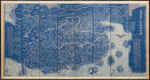
Complete Map of the Everlasting Unified Qing Empire (c. Da qing wannian yitong dili quantu), China, Qing Dynasty, Jiaqing period (1796-1820), ca. 1811, Eight-panel folding screen, wood block printed paper, blue on white, 112 x 249 cm., MacLean Collection[/caption]
Maps are rich cultural objects presenting and transmitting information about time and place of production. This lecture will provide some of the particular practices and relationships between text and image in East Asian map making that are unique in world cartography. It will present, through comparison, certain similarities and distinctive differences in the representations of space, both real and imagined, in early modern cartographic traditions of China, Korea and Japan and will also examine the introduction and some unique integrations of European map making techniques into these traditions.
Speaker:
Dr. Richard A. Pegg (BA ’83 and MA ’90 in Chinese and Japanese language and literature, GW) is currently Director and Curator of Asian Art for the MacLean Collection, outside Chicago, and author of the book Cartographic Traditions in East Asian Maps (University of Hawai’I Press, 2017).

