Map of Assam, India

Summer 2018 Research Fellow – Finding an Early Map of Assam

Map of Assam Jane Bennet, author of Vibrant Matter, might agree with me when I say that documents in the archives have thing-power. Thing-power, to her, is “the curious ability of inanimate objects to animate, to act, to produce effects dramatic and subtle” (Bennet 2010: 6).  A map is an inanimate object imbued with such thing-power. I do not refer here to the sense of exhilaration that a map is able to elicit in someone perusing the archives or an atlas, but rather to the capacity of the map to produce spatial order by locating things and people in relation to each other.

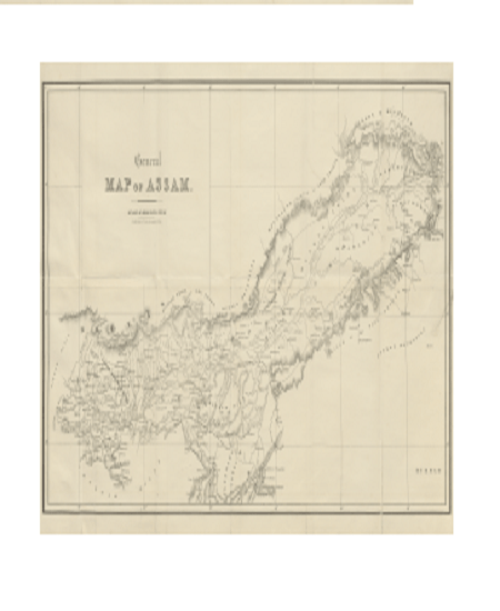
The map above makes the territory of Assam visible by positioning geographical features such as hills, mountains, rivers, and islands in relation to each other. The geographical features that are not sketched are almost as important as those that are sketched on the map. Together, they give this emerging territory of Assam its shape. Assam runs east-west along the river Brahmaputra, delimited in the north and the south by hills that are not fully sketched. The “outside” is allowed to remain an absolute space while Assam is sketched into existence.

Published in 1847, a century before Indian independence, this map sits within a book entitled Sketch of Assam. The author of the book only identifies himself as “an officer… in civil employ.” But he is identified in the archives as Major. John Butler, who was posted in the East India Company’s Bengal Native Infantry. Sketch of Assam is the author’s attempt to sketch—and by this I mean describe and typify both in writing and through drawings—some of the tribes that he encountered during his travels in Assam. By locating these tribes in the hills and in the valleys that fall within the delineated region of Assam as well as outside this demarcated space, he produces a sense of spatial relation between these tribes. For example, the hills to the south of the sketched region of Assam are occupied by the Nagas, locating the Nagas outside of Assam. To the north in another sparsely sketched section are the Abors. On the other hand the Meeree (spelled Meree elsewhere in the book) occupy a huge territory along the Brahmaputra within the territory of Assam. Today, the Nagas are understood to be indigenous to Nagaland and the Abors to Arunachal Pradesh both of which fall outside the territory of the Indian state of Assam. The Meeree are still understood to be a river tribe that live along the Brahmaputra in the state of Assam. Today, they are called the Mishing. I work in Mishing villages along the island of Majuli (Majouli, just south-west of the Meeree territory in the map), and am often reminded by my interlocutors that I should look for the word Meeree/Meree or Miri if I begin to dig into their history.

I was indeed digging for history, and I was excited to come across this book—and this map—in the Nehru Memorial Library this August. I was even more thrilled when I was able to locate it in a digital library and download it into my computer. For several reasons this map is a pleasure to examine. My dissertation examines how the Mishing deal with the massive erosion that haunts the island of Majuli today. This erosion forces them to question how they came to be on Majuli, where they came from, and where they were located before they were located in Majuli. Some of my interlocutors talk about the migration of the community from the hills to the north. Traveling down from the area marked “mountains inhabited by Abor Tribes” the Mishing believe they travelled down the river Subansiri, a tributary of the Brahmaputra to settle in both the territory marked as “Meeree tribe” on the map as well as the island of Majuli.  No one has a living memory of this migration. But it is collective memory, transmitted orally from one generation to another. This story allows them to claim relatedness to the Abor tribes of the north. In fact, in my first year I had a translator who came from the town of Ziro in Arunachal Pradesh. He was from the Apa Tani tribe. My Mishing interlocutors immediately took him under their wing, telling me he was “their own” while he was away from home, because of the historic relations between these tribes.

Butler too was interested in these relations. Despite his tendency to homogenize entire communities, he pays attention to nuanced power relations between these communities. He notes that the Abor were a powerful tribe and often lorded over the Meeree. While the Meeree migrated south in order to avoid being subjected to Abor lordship, the coming of the Khamtees from Burma into Assam, threatened their sense of independence. Afraid of being enslaved by the Khamtees, the Meeree sought help from the Abor. Butler notes that these tensions resulted in a violent conflict:

This treatment being less endurable than  that, of the Abors, towards whom a friendly feeling had been created by long intercourse, the Merees were induced  to implore the protection of the latter to save them from being cruelly taken away from their homes  to serve as slaves amongst a strange tribe. The Abors, on their side, perceiving that they were about to lose the greater portion of their slaves by the aggressions of a formidable foe, lost no time in preparing for war; and descending from their mountain fastnesses  to the plains bordering on the Dehong river, a furious battle was fought between them, and,  it, is said,  two or three hundred Khamtees. The contest terminated in the Khamtees being defeated and dispersed with great slaughter, upwards of one hundred men being left on the field of battle. This trial of strength and courage with their warlike neighbours, rendered the Khamtees ever afterwards more circumspect in their demeanour towards the Abors, and the people subject to them. (Butler 1847: 41).

It is interesting to see that while Butler locates the Abors and the Khamtees outside of Assam and the Meeree within Assam he avoids the use of militarized terms, i.e., language that implies a breach of Assam’s borders and its sovereignty. Instead he is very careful to note shifting alliances and the power relations between these communities. While he sketches Assam as a delimited territory, he is not too keen to treat migrations as breach of territorial sovereignty. Instead, he seems to indicate that territories are shaped by migrations. This emphasis on migration rather than invasion is similar to the emphasis on relatedness and territorial interconnectedness that Indrani Chatterjee (2013) makes in her study of monastic governance in Assam. Addressing the need to study the shifting relations between Hindu monasteries and the tribes rather than the supposed differences between them, Chatterjee critiques British historians such as Edward Gait for introducing a language that replaced relatedness with sovereignty and connectedness with isolation.

In further research, it would be interesting to see when exactly this language changed in the official British narrative. When did it become, for example, significant to speak about the invasion of Burma into Assam? How did this shift in language shape British narratives of the expansion of British rule into Assam? How does this new narrative treat the Meeree and their relations to Majuli and other places along the Brahmaputra? What differences does this produce in cartographic attempts to sketch Assam, and locate the Meeree within Assam?

References:

Bennet, Jane. 2010. Vibrant Matter. Durham: Duke University Press.

Butler, John, 1847. A Sketch of Assam: Some Account of Hill Tribes. London: Smith, Elder and Co.

Chatterjee, Indrani. 2013. Forgotten Friendships: Monks, Marriages and Memories of North-East India. London: Oxford University Press.  

Shweta Krishnan looking out a windowShweta Krishnan is a PhD Candidate in the department of Anthropology at George Washington University. Her research interests include the anthropology of religion, science and the environment. Her current project explores religious revival amid riverine erosion in the island of Majuli, Assam.


Shweta Krishnan sitting by a window looking outside

Summer 2018 Research Fellow – A Year After the Floods

Last year, thanks to a Sigur Center research stipend, I spent my summer on the river island of Majuli in the Indian state of Assam. In late May, my friends in the Mishing village of Sitadhar invited me to join them in celebrating Dobur, the festival that marks the end of the harvest and the beginning of monsoon. We gathered in a bamboo hut in the middle of the field, and offered thanks to the deities of Donyi Polo, the indigenous religion that several of the villagers observe. Not far from where we sat, ran the Luhit, a tributary of the Brahmaputra, that connects these villages to the town of Lakhimpur to the north of Majuli island. Between the prayer and the annual feast,  I walked along the banks of the Luhit, observing the rising waters and the swift current. That day cyclone Mora hit the coast of Bangladesh, and while Majuli was not hit by the storm itself, heavy rain pelted down all night and for most of the next day. Soon after, the north-east monsoon hit the shores of the island. I was scheduled to do some archival work in Delhi and as I headed from Majuli to the port of Nimati in Jorhat town, the currents got stronger and the river tore away the dock where we were supposed to land. Our boat was forced to make an emergency landing. When I called my friends in Majuli that afternoon, they seemed alright. The rivers were full, but they were simply wrapping up the harvest. But the next day, Luhit overflowed its banks and its waters ran ferociously into their fields, wreaking havoc. The Ganggin where we had prayed collapsed, shacks used to keep cows and pigs were damaged and several farmers lost their crop.

Eroded Fields, Sitadhar Majuli

This May, when I visited Majuli—again, in time for the festival—I was asked if I could spend some time helping the villagers set up their new Ganggin. Built close to where the old bamboo structure had stood, the new Ganggin, made of concrete conveyed a sense of sturdiness that seemed to assure them. The grounds we had very casually walked across only in the previous visit now had shallow craters. Large chunks of earth had been carried away, and even if the river had deposited a fresh layer of silt on these grounds, the uneven land was not as conducive to farming as it had once been. One of the farmers told me that he had not finished harvesting his crop when the floods hit. He had lost over 6000 rupees worth of rice, and had also been unable to salvage the corn he grew for personal use.

This year, working with his wife, daughter-in-law and son, this farmer planned to harvest faster than he had the previous year. But as the day for Dobur came closer, he also had to finish building and decorating the Ganggin. The concrete structure had no paint and it looked pretty stark amid the lush green fields. Hoping to brighten its facade, he asked me to make him some flags with coloured paper. The cheery paper, he hoped, would help people who shared this Ganggin forget that they had lost so much only a year ago, and instead remind them to celebrate the new place of worship and the good harvest.

The new Gangging with some of the flags we made.

I—and the good friend whose help I conscripted—spent a good three days making paper flags. Unable to find good crafts material in Majuli,  we planned a trip to the Gar Ali market in the town of Jorhat, where we picked up brightly colored paper, scissors, and tape. Back in Majuli, we wandered around the Goramur market looking for the right kind of chord to hold the flags together. As we sat sipping tea and cutting flags, we invited several questions from curious onlookers. After three days of cutting and tying and more cutting and typing we had flags of three different sizes and styles ready. On the morning of the festival, we worked with the farmer and his friends to decorate the place of worship. After the prayer, he gave us a locket with the Donyi Polo sign on it as a token of his gratitude and friendship.

The day after the festival most of my friends went back to the fields. The festival had come and gone, but the harvest was not quiet over. They worked with an eye on the sky, watching out for signs of the monsoon. I headed to Delhi for archival work, but called to check in when I heard that the monsoons had hit Assam. “This year, we had no trouble from the rain,” one of my interlocutors said. “In fact, we are going to be in trouble because I fear we did not have enough rain.”

I write this blog to call attention to the myriad ways in which people make life amid the erratic climatic patterns in the Brahmaputra Valley. Last year, the rains were heavy in Majuli, and the floods devastating. But where land wasn’t excavated by the flooding waters, the harvest was good. This year, the rains were not as heavy, and the floods not as fierce. But the farmers might have to be concerned about the crop. This uncertainty may not seem entirely uncommon; after all, farming communities have always had to deal with differing patterns of rainfall.

A large crater created by flooding waters in the Sitadhar fields.

But the excavated craters in their fields tell a different story. When Majuli becomes subject to devastating floods, it loses anything between 3.1 square kilometers to 8.5 square kilometers of land (Lahiri and Sinha 2014). Sometimes—like in the year 2005—entire villages have been washed away. Thus, uncertainty in Majuli is not simply a product of capricious monsoonal rain; it is tempered by the erosion of lived places. My dissertation examines how the Mishing draw on their religious ethical ideals, local knowledge, and other resources available to them to build a life amid erosion. As I get ready to wind up my summer, and start a whole year of fieldwork in Majuli two questions come up for me: What will it take for the bureaucratic institutions involved in the prevention of erosion in the Brahmaputra valley to begin seeing erosion, the changing rainfall and the floods as connected phenomena? In other words what will it take for them to recognize these events as part of the global phenomenon called climate change (Ghosh 2016)?  When they intervene will they learn from local efforts or will the techno-scientific machinery of the state efface local knowledges and practices that allow local communities to make life in this damage planet (Gan et al. 2017)?

References:

Gan, Elaine, Anna Tsing, Heather Anne Swanson,  and Nils Bubandt. 2017. Arts of Living on a Damaged Planet. Minneapolis: Minnesota University Press.

Ghosh, Amitav. 2016. The Great Derangement: Climate Change and the Unthinkable.Chicago: Chicago University Press.

Lahiri, Siddharthand Rajiv Sinha. 2014. “Morphotectonic Evolution of the Majuli Island in the Brahmaputra valley of Assam, India Inferred from Geomorphic and Geophysical Analysis.” Geomorphology227(2014):101-111.


Shweta Krishnan looking out a window

Shweta Krishnan is a PhD Candidate in the department of Anthropology at George Washington University. Her research interests include the anthropology of religion, science and the environment. Her current project explores religious revival amid riverine erosion in the island of Majuli, Assam.


indonesian coffee drink mixed with eggs with breakfast sides

Summer 2018 Language Fellow: Political Philosophy at Aceh’s Coffee Shops [Part 3]

What’s in a cup of coffee?

In the modern (read: neoliberal) world, coffee is a part of everyday life, the morning drink one picks up on the way to work. Coffee, or kopi in Indonesian, takes on a very different significance in Aceh. If in the modern world, coffee is an individualized drink that gives one the energy boost for the solitary work in the office, kopi is an inherently social drink in Aceh.

One of the things that I quickly learned coming to Aceh is that everything happens at the warkop (or warung kopi, literally coffee shop). It is Aceh’s community and social space par excellence, but many also use it as their “second office” (which is where most people get their wifi), classrooms, meeting rooms, consultation space etc.

coffee shop in Banda Aceh in indonesia
3in1 is a very large and popular coffee shop for youths in Banda Aceh.

Politicians, too, each will have their own “base camp” coffee shop, where their constituents can approach them freely. We even saw civil servants collecting the signature of a more senior civil servant in the coffee shop. Because the coffee shop is where everyone goes to, it is where all sorts of networks are formed.

Horas Coffee Shop shopfront in Indonesia bustling with customers
Horas Coffee Shop is one of the most famous coffee shops in Takengon. We also got a chance interview by just hanging out at this coffee shop.

For many Acehnese, the coffee shop is always contrasted to formal spaces. While the latter are felt to be rigid an uneasy (baku), the coffee shop is a place where rank and status disappear.

coffee shop with outdoor seating in Banda Aceh, Indonesia
Kuta Alam (City of Nature) is another popular coffee shop for young professionals in Banda Aceh

It is thus unsurprising that the coffee shop is an important site of contemporary politics in Aceh. Historically, coffee shops were important sites for the exchange of political ideas in Europe as well – it was the staging area before the actual revolutions. Perhaps in the modern world, the rental cost of land is so high that it is difficult, if not impossible, to see the coffee shop as anything other than a business. In Aceh however, the coffee shop remains an affordable site of political community and political action.

author of the article in a photo with local human rights activists in Indonesia
Chatting with a human rights activist (and running senator) at midnight.

This was not always the case however. Aceh’s civil war peaked in 2001-2004 when it was put under martial law. Curfews were imposed, and there were frequent spot checks on the roads. These practices, called “sweeping,’ isolated Acehnese from each other – which was part of the Indonesian’s military strategy of breaking up the separatist movement (Gerakan Aceh Merdeka). Ironically, it was between the years 1996-2004 that Aceh’s student activists’ networks would begin to form. A group that sided neither with the armed separatists nor the Indonesian military, this group rallied around the opposition to human rights violations from either side. They collected reports on human rights abuses and reported them to their networks around the world, hoping to use international pressure to restrain the Indonesian military; they also actively gave “political education” to the separatist combatants on non-violent struggle. Many of them also provided humanitarian relief to internally displaced people from the conflict.

author having a discussion with local Indonesian human rights activists at a coffee shop
A human rights activists recalled how they discovered the extent of the hidden civil war in Aceh’s interior; at one of the oldest coffee shops in Aceh

Where did these networks form? From the conversations we had with former activists in coffee shops, it seems that many of these networks began in Banda Aceh’s universities – where Acehnese from all over the province would go to (menrantau) get their degree. In the 1980s and 1990s, Aceh’s civil war had been largely fought under the radar, what the Acehnese refer to as DOM (Daerah Operasi Militer). The activists recall that nobody knew that there was fighting, or the extent of the conflict. They had been told that the Indonesian military were fighting drug smugglers or terrorists.

author with local indonesian human rights activists at a restaurant
Human rights activists recall how they were considered to be “crazy” for doing what they did; at Lhokseumawe.

By around 1996 however, university students in Banda Aceh got to have a better sense when they compared their experiences. By 2001, it was harder and harder to meet openly under marital law. Yet, university students found ways to meet, including in the meunasah (a small scale neighborhood mosque for the village).

customers sitting at an outdoor coffee shop in indonesia
Coffee Shop in the Village

These meetings didn’t merely involve planning mobilization, but entailed discussions of Karl Marx’s Das Kapital and Paolo Freire’s Pedagogy of the Oppressed, as one activist who majored in engineering recalled. It seems that what brought the student activist networks together was not merely shared grievances – either personal losses or a sense that the Acehnese nation was being violated. What made the movement unique was how they channeled their energy towards devouring “banned books” to make sense of what was happening, and what ought to be done. Unsurprisingly, many of these university students would take it on themselves to descend from the intellectual safe space in Banda Aceh back to the villages.

Today, these political networks can operate much more openly.

author posing for a picture with interviewees in indonesia
Talking to an ex-negotiator for the Aceh Freedom Movement. Today, he runs a coffee shop, coffee export business, and entrepreneurship school, believing that the economy is an important aspect of post-conflict rehabilitation.

Moreover, the preferred site of struggle is no longer with guns, but through democratic politics. Rather, the preferred site of political discussion is the coffee shop – where the likes of Marx, Friere, Gramsci or other revolutionaries are openly talked about – where political visions are born and networks made.

indonesian coffee drink mixed with eggs with breakfast sides
Kopi Kocok Telur (coffee mixed with egg)

Or, for that matter, over durians, the “King of Fruits:”

people eating durians outdoors at night in indonesia
Eating durians along the roadside

Below, a durian seller helps us open the durians:

So what politics / philosophy is in a cup of coffee?

cup of white coffee with cinnamon on top
“Wine Coffee” with Cinnamon

A lot, if we learn to pay attention.

Amor Hor posing with locals one a sidewalk in indonesia

Amoz JY Hor (center) is PhD student in Political Science at the George Washington University. His research explores how emotions affect the way the subaltern is understood in practices of humanitarianism.

cat and chinese script book on the table next to a glass

Summer 2018 Language Fellow- Writing, Speaking, Listening, and Embarrassing Yourself in Chinese

Hello! Let me let you in on a secret:

The secret to studying a language and speaking it is to utterly stomp your pride into the ground and make a fool of yourself on a daily basis. I’m proud to say that I have mostly managed to stomp my pride into the ground and then have thrown the remnants of that pride in the trash. Why, just today, I was pretending to be, first, a McDonald’s (麥當勞) fast food worker promoting the newest promotion (又快又好吃!), and then, second, a waitress attempting to convince a customer to fill out a form for a member card.

Fortunately, the entire reason I came to Taiwan was to learn Chinese. And if I must embarrass myself while improving, so be it.

a popular taiwanese pastry wrapped in plastic packaging
At NT$30, this is a popular dish at 曾家豆漿,a very popular breakfast place near me. While this place isn’t as famous as 永和豆漿, it delivers on quality every time.

Every day, my teacher, 吳老師 (Ms. Wu) attempts to coerce my classmates and I into making sentences using the grammar patterns and vocabulary from the textbook. Before each class, she asks us to prepare something. Sometimes we have to go and ask strangers on the street (!)  about the lesson topic. I think all students, regardless of their ability dread having to 做報告 (report) and speak to strangers but since most Taiwanese people are extremely friendly, it doesn’t matter if one embarrasses oneself as I did the one time I had to report on Taiwanese people’s favourite places in Taiwan.

After class, I like to go to the cafe right next to MTC’s building or a vegetarian 自助餐廳 (self-serve canteen). Sometimes, I also head to a cafe (cafe with a cat is preferred) to study, eat, or read. Here, it is fairly difficult to stumble over my words, but in the morning, at my favourite breakfast spot 曾家豆漿 (Zeng’s Soy Milk), I had no clue what anything was until I eavesdropped on other customers and discovered the name for a delicious and messy breakfast: 燒餅,加蔥蛋 (flaky sesame bread stuffed with a fried egg and green onions). Before that I just mumbled and pointed at my desired object.

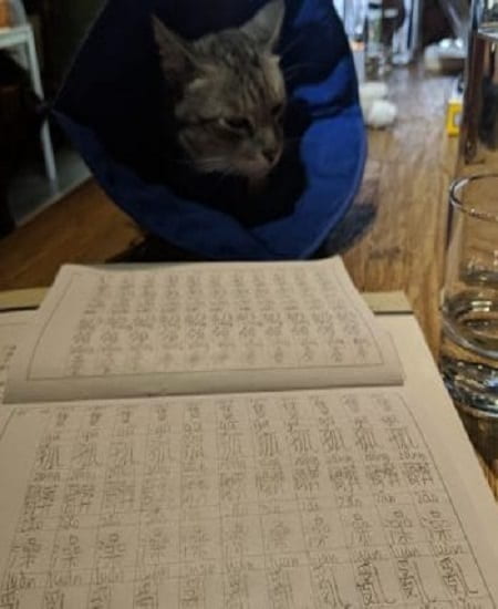
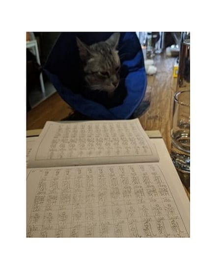
When studying Chinese one must also be willing to write characters repeatedly (see main picture). Each Chinese word has four components; the tone, the character, the Pinyin, and the meaning. When speaking, you must be very careful, as each sound in Chinese can have multiple meanings. For example, the word wen can mean “to ask” or it could also mean “to kiss”. It’s more likely that I have accidentally said 請吻 (“May I kiss?”) more frequently than 請問 (“May I ask you a question?”).

Since I originally learned 簡體字 (simplified characters), I was initially at a disadvantage. Thankfully, living in Hong Kong helped me to learn to read the majority of 繁體字 (traditional characters). I just couldn’t write the characters. In addition to teachers paying attention to those four aspects of Chinese characters, teachers are often able to discern the order in which a student writes a character, forcing students to write exactly in that order. Luckily, we do not have to learn this character:

the most complicated chinese character in existence
At 57 strokes, this character, biang, was apparently once used to punish wayward students. This character is actually onomatopoeia to represent the sound of noodles slapping the counter.

Aside from the obvious option of venturing outside and speaking to locals, MTC also encourages students to attend additional sessions. From Chinese in the Media (last class we discussed a famous Youtuber’s visit to the hidden snacks of 淡水), Chinese Cuisine and Dining ( last class, we discussed 東坡肉 -a layered cut of heavily marinated pork- and its history), to Taiwanese for Beginners, all of these classes attempt to encourage students to speak and participate more but most students are shy.

My favourite class is actually the class where we watch Time Story (光陰故的事). Though it doesn’t give me a chance to practice speaking Chinese, its actors all have different accents from Taiwan and the mainland. If one wishes to learn Taiwanese, one could also attempt it by watching this series. Sadly, I believe Taiwanese is beyond me even when I am reading the subtitles.

Roald Dahl book translated into Chinese
I like to pretend I look super smart when reading 瑪蒂達 but this book is at a 10-year-old reading level in Chinese as well.

Finally, I have bought a book in Chinese to improve my reading Chinese skills. Unlike English, Chinese can be divided into written and spoken Chinese. This means that when you are reading, you’ll most likely see characters you’ve never learned or never speak in daily conversation. My choice of reading is 瑪蒂達. I haven’t read the book in approximately 20 years, but it is just as hilarious as I remembered. And it is really helping me to learn some very interesting words. It does feel slightly odd to be reading what is an elementary school level book in public, but when your Chinese reading level is at an elementary school level, that’s the only choice you have.

Until my next post, I’ll continue to embarrass and simultaneously learn Chinese while entertaining the citizens of Taipei to no end.


Picture of Lexi Wong in pink shirt

Lexi Wong M.A. International Affairs 2019
Sigur Center 2018 Asian Language Fellow
National Taiwan Normal University, Taipei

Lexi Wong is a Sigur Center 2018 Asian Language Fellow studying Mandarin in Taipei, Taiwan at National Taiwan Normal University’s Mandarin Training Center. Lexi is currently a first-year graduate student at The George Washington University’s Elliott School of International Affairs where she is studying International Affairs with a regional concentration on Asia. 

a team of people loading a coffin to its free-of-charge funeral transportation van

Summer 2018 Research Fellow – Rest in Peace Myitkyina: A Case Study in Local Initiatives and Provision of Public Goods in Myanmar

a team of people loading a coffin to its free-of-charge funeral transportation van
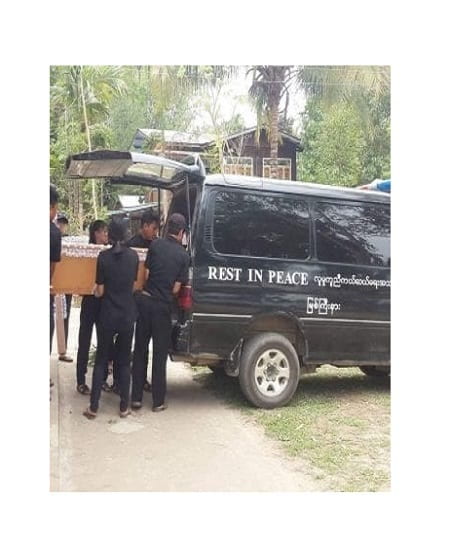
The RPM team loading a coffin to its free-of-charge funeral transportation van

Myanmar Rescue – Kachin, locally known as Rest in Peace Myitkyina (RPM), is a Myitkyina-based rescue team in Kachin State, the northernmost state in Myanmar. It was first founded in 2012 and since then have become an integral part of the local communities across Kachin State.

When the group was first established, its initial aim was to provide free funeral transportation in the Myitkyina area. This of course is a much-needed service in all localities across Myanmar. The vast majority of the people of Myanmar cannot afford to own a vehicle of any kind. In fact, according a recent survey conducted by the USAID in partnership with the Myanmar Ministry of Health and Sports, only 5% owns a car or truck. Therefore, transporting caskets to cemetery, let alone the funeral attendees, can be a daunting task. There were church-based funeral transportation services in Myitkyina, but they typically “suggest” a donation of 60,000 kyats (about $45), which was not affordable for many families. There were also Buddhist-monastery-based funeral transportation services which were free, but religious-community-based service provisions rarely ever cut across religious line in reality even though they are not meant to be so. This is why the founder of RPM, who is an ethnic Kachin and a Baptist, had a difficult time finding an affordable funeral transportation service when his father passed away. The challenges, both emotional and physical, inspired him to start a community-based free funeral transportation service that is detached from religious affiliation. The group began with just 8 individuals who were all close friends of the founder. Today, there are more than 50 volunteers (all unpaid) ranging from teenagers as young as 13 to 65-year-olds.

Since founding the group’s activities have expanded to include ambulatory service, transportation of dying persons (and sometimes already deceased) from the hospital to their homes, and anything rescue related. For example, when two local boys drowned in the Irrawaddy River, but the bodies had not turned up, the RPM was contacted to search for the bodies. The geographic converge of the service has also necessarily expanded to regions outside of Myitkyina. That is because other localities in Kachin State lack free and reliable rescue services, and also because given that Myitkyina is the capital city of Kachin State, its general hospital, perhaps the most comprehensive and advanced hospital in the state, receives patients from all over the state. Sometimes a family in Danai, about 80 miles northwest of Myitkyina, would contact RPM to transport their loved one to the Myitkyina hospital. Sometimes, the hospital staff would call RPM to transport dying patients to Hpakant (70 miles from Myitkyina), Waingmaw (across the Irrawaddy river from Myitkyina), and Chipwi (close to the Chinse border). Because RPM responds to emergency situations, it is always ready to go regardless of the time of day (the night I talked to the group, they brought a cordless landline phone with them and warned me that they might have to interrupt our conversation and get going should the phone ring), and teams of volunteer rotate for night duty.

Such geographic expansion comes with more interaction with the authorities at check-points (there seem to be a check-point before entering any township in the state). Some check-points cannot be passed between 6pm and 6am. An RPM volunteer recalled a time when they were transporting a deceased person from the general hospital to Waingmaw around mid-night and had to wait at the check-point until 4am to be allowed to pass.


a team of people carrying a coffin to a burial plot at a local cemetery
The RPM team carrying a coffin to a burial plot at a local cemetery

RPM is just one of many incredible local initiatives that grew into much needed public goods. The government in Myanmar is simultaneously big and small. It is big in a sense that its public administration span from the union government (akin to the federal government in the U.S.) all the way down to all ward and village tracts, which is the lowest level of administration unit, across Myanmar, including the border area. Its hierarchical and expansive nature allows the government to extend its presence to every corner of Myanmar (except in the rebel control areas), yet it is unable to adequately provide its citizens’ basic needs such as street lights, drains, road construction and repair, emergency service, etc. (and we haven’t even started talking about the state of government-provided welfare in Myanmar). And it is not clear when it will be able to step up to provide these basic needs. Right now, in many localities across Myanmar, it is the ordinary citizens who are taking charge to come together to dig drains and wells and even provide 24-hour emergency service.


Jangai Jap profile picture in black and whiteJangai Jap, Ph.D. Political Science 2021
Sigur Center 2018 Field Research Fellow
Myanmar

Jangai Jap is a Ph.D. Candidate in George Washington University’s Political Science Department. Her research interest includes ethnic politics, national identity, local government and Myanmar politics. Her dissertation aims to explain factors that shape ethnic minorities’ attachment to the state and why has the state been more successful in winning over a sense of attachment from members of some ethnic minority groups than other ethnic minority groups. She has won the National Science Foundation Graduate Research Fellowship, and her dissertation research has received support from the Cosmos Club Foundation and GW’s Sigur Center for Asian Studies. 

view of a beach from a beach tent

Summer 2018 Language Fellow – Video Blog: 去外澳海灘走一趟


大家好!既然我在台灣學中文,就應該多練習吧!為了喬治-華盛頓大學Sigur Center部落格的要求,我上個週末拍一段視訊。麻煩大家忍我用一些台灣的說法。部落格就是博客,視訊就是視頻。這只是一些台灣跟中國不同說法的例子。雖然從開始學中文起,我一向學簡體字與中國大陸的說法,但是在台灣的過程中,我很認真地試一試學繁體字。

由於在華盛頓的時候我的空很少,因此我決定趁這個在台灣難得的放假去宜蘭的外澳海灘衝浪。來台灣之前我十年沒衝浪,所以第一次試試看在衝浪板站起來就倒在水裡。台灣的氣候與地理帶來了很多生物多元化。看我拍的視訊之後,你就可以了解台灣的風景究竟那麼好看。根據古老的成語來說,「上有天堂下有蘇杭」不過若是古代的哲學家當時有機會來台灣享受自然的美麗,那麼那個成語的確讀作 「上有天堂下有台灣!」


Headshot of Alex Bierman with brick backgroundAlex Bierman, M.A. Security Policy Studies 2019
Sigur Center 2018 Asian Language Fellow
National Taiwan University, Taiwan

Alex Bierman is a M.A. candidate in Security Policy Studies focusing on East Asian security and cyber security. His interests include U.S. policy towards East Asia, Cross-Strait policy, and Chinese politics.

Summer 2018 Language Fellow – Taiwan’s Colors

Picture of Taroko National Park in Taiwan

Views of Taroko National Park, once home to the aboriginals.

person holding a baseball in their hand overlooking a baseball stadium

Baseball, the national sport of Taiwan, is great to watch when a player throws you a ball as a souvenir.

How can I begin to talk about Taiwan? For such a small country where you can go from one end to the other in about 4 hours, it hides an enormous amount of natural beauty, modern technology, history, and my personal favorite, bubble tea. Every city gives off a different feeling. To me, among some of the easily reachable cities, Taipei represents industry and advancement, Taichung, as the city where the aforementioned bubble tea was founded, epitomizes food and beverages, and Kaohsiung signifies art and expression. There is never a shortage of the kinds of places that satisfy any given mood.

There are a few conditions that I use to rate my experiences in certain countries: Uniqueness, History, Nature, Entertainment, Price, Transportation, and Hospitality. Uniqueness encompasses concepts such as culture, heritage, and tradition; ultimately, they are things I can do that are specific to the area. History indicates important cites, buildings, memorials, or the like, where I can go to better understand what happened in the past and honor the sacrifices people have made. Nature means the overall preservation and protection of natural resources, such as mountains, reserves, parks, and oceans. Entertainment implies the availability of fun activities that are not specific to any region, but are usually recognized as fun, such as ice skating, while Price is the average cost of living and how much it hurts my wallet (and subsequently my heart). Transportation is the extent of public access to other destinations via a vehicle. Finally, Hospitality quantifies the attitude of the public and their willingness to communicate when I have questions. This system is in no way a grading system for the public to take heed of, but rather a personal one. Needless to say, Taiwan ranks high in each category and has left an irreplaceable impact in my heart.

Releasing lanterns into the sky in Pingxi, visiting a plethora of night markets, climbing to the top of Jiufen, which inspired the popular movie Spirited Away, and admiring the view, walking along Kaohsiung center amidst trolleys, people, huge interactive pieces of art are just a few of my inimitable experiences in Taiwan. Influenced by the Dutch, aboriginals, and of course the Chinese, Taiwan gives off a distinctive blend of culture and exhibits them most exquisitely within their libraries, memorials, and museums. Furthermore, their huge national parks, each characterized by something special, such as volcanic sulfur or waterfalls, are most beautiful and worth seeing. Some are even close enough to cities to take a day trip to and spend the day relaxing away from the hustle and bustle of a metropolis. Not just that, but smaller parks are also abundant and brimming with life, while the streets are decorated with lovely sprinkles of trees and plants. Entertainment and Price go hand in hand, and both are very reasonable. The former is extensive, and depending on the area of popularity, such as karaoke in Asia, more or less expensive. Nevertheless, it is very doable. To be quite honest, while its transportation is far-reaching in terms of inter-cities and inner-city transit, I have a difficult time making my way out of the general public and into smaller villages, lesser known areas, or some parks. However, I do not think this is an issue of the country itself, because renting a motorcycle is a valid, safe, common, and cost-efficient solution. However, I have forgotten to bring my license and thus my inconvenience is a result of my thoughtlessness. Lastly, although I have observed that Taiwanese people are a commonly caring and helpful people, they are nervous to approach foreigners in fear that they will need to speak English. Even in markets where one must latch on to potential customers, shop attendants or stall owners stand watch at a corner and don’t approach unless I have proven myself to speak Chinese. While this is slightly disappointing in that I can be afraid to make the first move, especially when speaking Chinese, it does give me a reason to push my limits and step out of my comfort zone to better my language abilities. For this, I am thankful.

Although I sadly don’t have much remaining time here, I hope to make the most of it by exploring and experiencing everything that I can. I am eternally grateful for having the opportunity to reside, albeit for a short period of time, in such a wonderful enigma of a country!


selfie of Zeynep Hale Teke in blue shirtZeynep Hale Teke, B.A. Applied Mathematics 2019
Sigur Center 2018 Asian Language Fellow
Taiwan Mandarin Institute, Taiwan

Hale is a rising senior studying Applied Mathematics in the College of Arts & Sciences department at GW. She fell in love with Mandarin and Chinese culture (especially the bits involving food) after her first Chinese class freshman year and does not plan to stop studying it until mastery. Her eyes not only opened to the infinite wonders, sounds, and beauties of Taiwan, but also how deep the Mandarin language really is.

buddha statues inside a cave

Summer 2018 Language Fellow – Digging Into Datong

Hi again! This last week or so has been a whirlwind of activity, as directly after our midterm exam, we made our way to the train station to catch our sleeper train to the city of Datong (大同市), in Shanxi Province. Unfortunately, due to the recent severe rainfall resulting from a hurricane near the coast, the train tracks outside of Beijing were covered in water, and our train was delayed three hours while the tracks were cleared. We eventually made it on the train, and settled in for the six-hour journey. Many of us napped, some did homework, others played cards or chatted amongst themselves or with other friendly passengers, and though we arrived in Datong rather late, overall it was an enjoyable experience.

parking lot in China at night

Our first full day in Datong was our busiest, we climbed Mount Heng, visited the Hanging Monastery, and admired the world’s tallest wooden pagoda. Mount Heng, or Hengshan (恒山) is the northern mountain of the Five Great Mountains of China, the most renowned mountains in Chinese history that were regularly the subjects of imperial and common pilgrimage. Hengshan is about an hour drive southwest of central Datong, and is littered with Taoist temples and shrines to mountain gods dating back to the Han dynasty.

small gate at a historical site in China

We hiked from the parking lot to one of the highest vantage points on the mountain, although unfortunately didn’t have time to make it all the way to the top. The lush forests and nearby lake made for breathtaking scenery, and it was with regret (and rumbling stomachs), that we made our way down the mountain for lunch.

 natural scenery from mountaintop in China                             path leading to a monastery in China

After, we visited one of Datong’s most popular attractions, the Hanging Monastery. The Hanging Monastery (悬空寺) clings to a crag of Hengshan, and is dedicated to three religions, Buddhism, Taoism, and Confucianism. According to legend, was built by a single monk, Liaoran (了然), in the late Northern Wei dynasty to appease the severe yearly flooding in the region.mountainous rocks on a river in a scenic area in China

Wooden poles drilled horizontally into the cliff face and vertically into the surrounding rock support the monastery’s 40 halls and pavilions. The temple is protected by the summit from rain and sunlight erosion, which along with its location well above ground level (and a restoration effort in the 1900s) has left the monastery remarkably well-preserved.

 walkway and tourist area attached to the side of a mountainous rock                                narrow walkway at a monastery in China

Our final stop was one of the tallest wooden pagodas in the world, again about an hour from Datong. The Sakyamuni Pagoda is a wooden pagoda built inside the Fogong Temple complex in 1056, during the Liao dynasty. It has survived several earthquakes and although severely damaged during the Second Sino-Japanese War, was quickly repaired, and today is the oldest fully extant wooden pagoda in China.

  pagoda at a Chinese tourist site                                  pagoda at a Chinese tourist site with a boddhisattva statue in front

After returning to downtown Datong, my classmates and I, exhausted from the sightseeing,  quickly ate dinner and went to bed.

Our second day in Datong was our last, after breakfast we trekked out to our last site, the Yungang Grottoes, before boarding our return train to Beijng. The Yungang Grottoes  (云冈石窟) are ancient and massive Buddhist temple grottoes, located about half an hour west of central Datong.

group photo in front of  massive stone buddha statues carved into a grotto

There are 53 major caves and 1,100 minor caves, excavated during the Northern Wei dynasty, which are today part of a large outdoor complex including several gardens and other historical buildings.

            buddhist structures inside massive cave                                   buddha statues inside a cave

Since the caves and cliffs are sandstone, the grottoes and Buddhist statues inside have been exposed to heavy weathering over the years, especially the ones exposed to the open air. The wooden buildings in front of many of the cave entrances were constructed during the early Qing dynasty, built in an attempt to preserve the caves.

wooden buildings built into sides of caves as an entrance to a buddhist cave temple

After viewing the caves, we took a short shuttle ride to another part of the complex for lunch and some light shopping, before packing up our things and returning to Beijing. The trip back was much like our journey there, with several rousing games of Uno and a serious game of weiqi being played along the way.

   group of people in a shuttle                            girl sitting up reading a book on a shuttle bed

After arriving at our university, although some students had hoped to rally and head to Sanlitun (三里屯), an area known for its foreigner-friendly clubs and bars, most of my classmates and I promptly passed out, and woke up late on Sunday, ready to face the coming week (although less ready to do the homework most of us had neglected)!

Next weekend, I’ll travel with some classmates to Qingdao, in Shandong Province, so keep checking back for updates on the fun!


headshot of Katherine AlesioKatherine Alesio
B.S. Civil Engineering 2020
Sigur Center 2018 Asian Language Study in Asia Grant Recipient
Minzu University of China – Associated Colleges in China Program

A beach coastal area in Pulau Weh, Indonesia

Summer 2018 Language Fellow: Aceh’s Natural Beauty [Part 2]

There is little doubt about the resplendent natural beauty Aceh has to offer. For one, its beaches are absolutely serene:

A beach coastal area in Pulau Weh, Indonesia
Paradise at Pulau Weh


Turquoise body of water in Indonesia
How can water look so turquoise?


Breakfast area under a shade near a body of water
Breakfast
person sitting on a hammock at a beach
Post-swim


These beaches are on an island off of Banda Aceh called Sabang or Pulau Weh. I didn’t have an water-proof camera to show pictures of the incredible colours of marine life one could witness underwater.

It was also fun that we got around on “mario carts:”

cars on a road in the countryside of Indonesia


a cart on a dirt road in Indonesia


person posing on a cart near a beach in indonesia

From the beaches down below, Aceh has magnificent mountains above as well. Another popular location is the coffee growing region of Takengon:

river, mountains, and nature in indonesia
Mosque under the Mountains


open rice paddies with mountains in the background
Open padi/rice fields, in the mountains


backyard rice field with open space and mountains in the background
Backyard Padi


fish farm at a lake with mountains in the background
Fish Farm in the mountains, Lake Laut Tawar


lake with boats and fishing gear


Gayonese coffee is internationally renown, and grown right here:

shelf with lots of plants and a sign in indonesian
“Seladang: Have your Coffee in the Coffee Garden”


coffee beans that are ripe and unripe
Ripe and not yet ripe coffee
coffee beans in a person's palms surrounded by leaves
Where coffee comes from: the seed of the coffee fruit


Moving south, here’s a shot of a beach in Meulaboh:

sunset near the ocean over a cave
Sunset over the Bat Cave

Even Banda Aceh, the capital, has terrific sights:

fisherman pulling on a net at beach in the sunset
Fisherman at Lho Nga


a crowd assembling for the sunset and fishermen returning from the sea
A crowd assembles for the sunset and returning fishermen


a road between the ocean and an aquapond
The road between ocean and aquapond


colorful boats at a pier in indonesian countryside
Coloured Boats

As a claustrophobic city kid who grew up in Singapore, even the sight of expansive open green space (with a volcano in the backdrop) absolutely takes my breath away.

person sitting in a yard overlooking a farm and natural scenery

In my most recent trip, I heard that Singapore was often used by separatists’ propaganda as a posterboy of what Aceh could look like if only it got independence. While Singapore can often be attractive as a model of catch-up development in Asia, I wonder what gets lost in the pursuit of “development” – nature, but also heritage and spirit – themes that Singaporeans are all too familiar with.

people in grassy area searching for gravestones of different eras
Searching for heritage: each grave stone comes from a different era

Ironically, even as Acehnese are looking to Singapore for a model of development, Singaporeans are looking to retrieve something that which has been lost through their experience of development, that which has been endearingly called “the kampung spirit,” or the spirit of community (associated with the village).

a local outdoor coffee shop with many customers
The hometown coffee shop of a friend. The architecture encourages maximum ventilation for the tropical weather.

For many Acehnese, the site of the community is in the WarKop (Warung Kopi, or Coffee Shop). I will take up this theme in my next blog post.

Amoz Hor near a beach looking out at the ocean Amoz JY Hor is PhD student in Political Science at the George Washington University. His research explores how emotions affect the way the subaltern is understood in practices of humanitarianism.


boat on a house roof after the tsunami in indonesia in 2004

Summer 2018 Language Fellow: Aceh 13 years after the Tsunami and Beyond [Part 1]

My fieldwork site is in Aceh, Indonesia. Aceh is at the western most province of Indonesia, and is known as the historical gateway to Indonesia – from economic trade, to cultural, political and religious influences.

colored map of the Asia Pacific

This point is literally what is called “Zero Kilometer,” referring to the western most tip of Indonesia:

indonesian flag flying on a coast side near the water

Aceh is probably most known by foreigners for being hit by one of the most devastating tsunamis in recorded human history – the boxing day tsunami of 2004.

satellite view of Aceh, Indonesia after the tsunami in 2004

The magnitude of the tsunami was met with one of the largest humanitarian responses in the history of humanitarian responses. Crucially (and the subject of a future post), the tsunami also brought an end to a 30 year-long civil war.

Below is an aerial photo of Banda Aceh (the capital) today:

Bird's eye view of Aceh filled with greenery and buildings

(source)

The oval-shaped building at the centerpiece of the above photo is the state-of-the-art Tsunami Museum, also pictured below:

Image of aceh tsunami museum

(Source)

This is not to say that Aceh has been “built back better” without complications after the disaster. Some aspects of the destruction are irreversible. Apparently, there was a land bridge to the island pictured below before the tsunami (the waterbody was originally a lagoon). Now, the village from the island cannot return to their ancestral land

black and white photo of a landbridge in indonesia

Banda Aceh’s urban landscape is also unsurprisingly replete with memorials of the tsunami. Below is a picture of a boat that was swept on top of a house after the tsunami. It has now been preserved.

boat on a house roof after the tsunami in indonesia in 2004

The landscape also includes structures such as the one below which people can run to in the case of another tsunami.


One challenge of such structures is that they are often left unused and thus lack maintenance because they do not serve other functions. This can be seen from the interior below:

the inside of a building left unused

From the sky, one can see the colored patterns of tsunami houses – houses built from the tsunami reconstruction. There are different colored patterns because different NGOs would reconstruct different communities’ houses, and is seen today as a symbol of inter-NGO politics that characterized the reconstruction.

aerial view of tsunami houses in indonesia

Below is a street-view of a tsunami house. Some of these houses are empty today, especially those that were rebuilt in locations that are no longer inhabitable. For example, few live next to the coast worst hit by the tsunami – not only are many still traumatized by the ocean, but many of the aquaculture ponds (that were the main source of livelihood for the communities that used to live there) are beyond rehabilitation. I was told that it is not uncommon that such neighborhoods are inhabited by students who have moved to Banda Aceh for study – the ones who need cheap accommodation and have little alternative.

a small tsunami house in indonesia surrounded by grass

Although the boxing day tsunami grabbed headlines all around the world, the 30 year civil war (most of which was kept secret, and ended shortly after the tsunami) has gained less attention. Tellingly, in comparison to the tsunami, there is very little memorialization of the conflict, even though both ‘events’ registered over a hundred thousand deaths, with the latter occurring over a 30 year period, and thus leaving a much deeper impact on the Acehnese’s social pscyhe. Below is one of the memorials that have been erected to remember a torture center in Pidie, Aceh. It is a stark difference from the tsunami museum pictured earlier. Although such a memorial is surely sensitive to the central government, the Acehnese we talked to are clear-headed that remembering the conflict in a fair way is important to learn from their history.

memorial of an event from the indonesian civil war

Crucially, it is problematic to reduce the Acehnese identity to victims of either the tsunami or the conflict. Aceh has a rich heritage that not only extends much further back into history, but also much further into the present. In these narratives, the Acehnese are not merely victims, but actors in their own rights – fighters, activists, humanitarians, each with different ways of exerting agency over who they are and their future. If we pay attention, they also offer lessons for the world.

person running along the sunset at a beach

I will take up some of these themes in my upcoming posts.


headshot of Amoz JY Hor with white background

Amoz JY Hor is PhD student in Political Science at the George Washington University. His research explores how emotions affect the way the subaltern is understood in practices of humanitarianism.